Distance: 6.25 Miles
Vertical Gain: 3000'
Group Size: 4
Hike Rating: Easy Moderate Hard Strenuous
 GPX
for
this trip
GPX
for
this trip

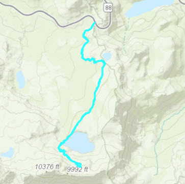
| Start Coordinates: | N 38 41.697 W 119 59.363 | End Coordinates: | Same as Start Coordinates | ||
| Car Shuttle Req'd: | No | Parking Directions: | Take Highway 88 to the parking area at the Carson Pass information station on the
west side of the road. Pay the day use fee (summer only) and find the trailhead just to the right side (north) of the information station itself. |
||
| Hazards of Note: | Steep incline on the heading up above Lake Winnemucca with some Class III rock hopping. Route finding
is required in this section. |
Crowd Factor: | High followed by Minimal. The Lake Winnemucca Trail is one of the more popular trails in the entire Mokelumne Wilderness and there will be many people on this part of the hike. Once you turn off to make the climb to the tarn, there is very little chance of running into anyone. | ||
| General Notes: From the parking area head toward Lake Winnemucca. Past the lake, head up the trail toward Round Top Lake, and when you get to the open area begin the climb up above the lake, looking for a negotiable path up above the lake. If you get up too high there will be significant rock climbing required so stay as low as possible without being too close to the edge of the area above Lake Winnemucca. Follow the water flowing down the small valley until you reach the tarn. |
|||||


