Back to index Mt. Reba Hike
Trip Date:  7/22/2020

Distance: 7.0 Miles

Vertical Gain: 1800'

Group Size: 1


Hike Rating:  Easy  
Moderate   Hard   Strenuous
Mt Reba Hike
See video of this hike  See video of hike   Download GPX GPX for this trip
Mt. Reba Elevation Profile
Start Coordinates:   N 38 29.109, W 120 01.177     End Coordinates:   Same as Start Coordinates
Car Shuttle Req'd:   No Parking Directions:   Take Highway 4 toward Bear Valley Ski Resort.  Turn north onto Highway 207 and find the Round Valley Sno-Park parking area less than 1/10th of a mile on your right.  Trailhead is just to the left of the bathrooms.
Hazards of Note:   Rocky, loose gravel along the 4WD road up toward the top of the ridgeline.  Possible 4WD vehicles on the trail as well.  Bears, Mountain Lions and the usual outdoor creatures frequent areas near the Highway 4 corridor.

Crowd Factor:   Minimal.  Although you might run into a vehicle or two slowly climbing their way up to the ridgeline on forest route 7N93, the main trail on this hike, you will probably not enounter many people accessing either the Underwood Valley or the Lake Valley trails into some very rugged sections of the Mokelumne Wilderness.
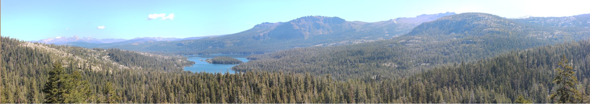
General Notes:
From the parking area at the Round Valley Sno-Park, head toward the signed gate for forest service road 7N93 and begin a very steep and surprisingly tiring first mile to mile and a half along this road.  You will gain over 800 feet of elevation on this section, and the loose footing and soft dirt mixed with some granite rocks for vehicle traction can make this even more of a workout.  Once you reach the first plateau and the trail turns from heading north to heading east, you will see some rocks marking an alternate route back down to Highway 207 a little further north of where our trailhead started.  Along this plateau are some fantastic views to the south toward Lake Alpine, Spicer Reservoir and the bulk of the Carson-Iceberg Wilderness.  Especially notable from here are the Dardanelles in front, 3 Chimney Peak far in the distance to the south and Sonora Peak a good 25 miles away to the southwest.  
After crossing this plateau the trail will start back down a little ways, and there will be an easy to miss junction to the right if you wanted to take the Bee Gulch trail back down to Lake Alpine, and alternate route up to Mt. Reba.  Continue straight on, and avoid the meandering side trails which appear from time to time.  Your next objective is going to be the large hill directly to the north, and you can either take the road which has a switchback up to the top, or find the use trail that others have used to directly head up to this point.  From this vantage point you can see down into the Underwood Valley, as well as along the northern side of the Wheeler Peak ridgeline.  Not visible from this area is Wheeler Lake, but it is beyond the ridge to the east.  Look carefully and you will spot the roof of a building down below your  vantage point that is in the Mokelumne Wilderness but whos history is a mystery at this time.
From this point keep heading up the ridgeline, gaining elevation quickly.  At the top of this next ridge is a view into Lake Valley, and the trailhead for what used to be the most travelled path between Tahoe and Yosemite, down into the deep canyon to the north toward Camp Irene.  This trail become mostly abandoned once the Pacific Crest Trail (PCT)  was completed.
Continue almost due west, dropping down a little bit before heading back up again on the final ascent of Mt. Reba.  The large rocky section is the peak proper, although the ridgeline from this point also extends north at nearly the same elevation for another quarter mile.

In the middle of the week in the summer during a Covid year, there wasn't much of a battle for a good parking spot in the Sno-Park. Parking area
The start of Forest Service Road 7N93, the track you will take for the majority of the hike up to the ridgeline.  Most of the road is in decent shape, but there were a couple of sections that would have had me turn around while by myself even with 4WD. Trailhead
The road is very steep, but there are some nice sections with an abundance of wildflowers growing on both sides of you.   Nice walk 
An early glance toward the ridgeline we will be heading up toward later on the trek. Ridgeline
Mokelumne Peak, deep in the heart of the Mokelumne Wilderness makes an early appearance.  It will be visible for much for much of this day.
Moke Peak
There was one family who we saw heading up to the first plateau in a jeep, but there were sections I was going up the same speed. 4WD option
Smoke in the air from the recent "Hog" fire in Sierraville obscured some of the distant views, but still a good look at the Carson-Iceberg Wilderness south of Ebbetts Pass. Carson-Iceberg
Walking the ridgeline to the east looked like it might not be that easy with a volcanic protrusion blocking the way. Closer 
Easy to miss but close to the trail on this first plateau is a nice overlook of Lake Alpine.  The Bee Gulch Trail heads up toward Mt. Reba from the shores of this lake, which would add to the overall elevation gain from that origin. Lake Alpine 
Don't you just hate when people leave their poop right in the middle of the trail without bothering to clean it up? Bad form
Finally at the top of the first rise, at the trailhead for the Underwood Valley trail you could see far into the Mokelumne Wilderness, especially with Summit City Canyon directly in front.  In the furthest distance you could make out Thunder Mountain in the left middle of the picture and even Round Top to the right. Underwood Valley
To the east was Wheeler Peak in the left foreground and the distinctive Raymond and Reynolds Peaks in the distance. Looking east
To the northwest, as imposing as ever was the sight of Mokelumne Peak and the Mokelumne Tetons below it. More Mokelumne
Now only about 3/4 of a mile away, the peak was in sight and it was pretty smooth sailing from here to the top across the open ridgeline. Toward the peak
Although the peak itself isn't especially memorable on its own, the views from the top in all directions make it one of my favorite of the many I've climbed. The Peak
To the west, Salt Springs Reservoir a good 4 thousand feet below our spot. Salt Spring Reservoir
Even my dog Tahoe was suitably impressed, or wanted to take a swim. Tahoe enjoying the view
Also to the west was a conspicuous dirt road heading down toward the river far below.  Behind it, but not visible, is the Grouse trail which on the map heads down from the ski area to dead end in the valley below. Bear Valley Ski Area
Although smokey, the views to the east were still pretty impressive. Looking east
Although so close to this popular ski resort, Mt. Reba itself was quiet and isolated and a fantastic destination on the day. Bear Valley Ski Resort
Heading back along the ridge I spotted another trailhead from the top down toward Lake Valley.  It looked like this one was going to meet up with the earlier trail down toward Camp Irene. Another trailhead
Came across this interesting tree on the ridgeline which looks like it has had a tough life up to this point. Interesting Tree
Back at the car, there was one tired pup to load up for the drive home. Tired pup 
GPS Track of the full hike, starting from the lower right and heading up to Mt. Reba in the upper left. GPS Track of Hike